
Thank you for supporting this site ❤️
Make a donation
Make a donation
Gear up for your next adventure:
As an Amazon Associate, this site earns from qualifying purchases at no extra cost to you.
M'daourouch topographic map
Click on the map to display elevation.
Thank you for supporting this site ❤️
Make a donation
Make a donation
Gear up for your next adventure:
As an Amazon Associate, this site earns from qualifying purchases at no extra cost to you.
About this map
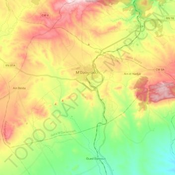
Name: M'daourouch topographic map, elevation, terrain.
Location: M'daourouch, M'Daourouch District, Souk Ahras, 41001, Algeria (36.00454 7.71813 36.12094 7.92726)
Average elevation: 2,756 ft
Minimum elevation: 2,087 ft
Maximum elevation: 3,589 ft
Thank you for supporting this site ❤️
Make a donation
Make a donation
Gear up for your next adventure:
As an Amazon Associate, this site earns from qualifying purchases at no extra cost to you.
Other topographic maps
Click on a map to view its topography, its elevation and its terrain.
M'Daourouch
Algeria > Souk Ahras > M'Daourouch District > M'daourouch > M'Daourouch
Average elevation: 2,815 ft