Geolocate

Kaoota topographic map

Click on the map to display elevation.

About this map

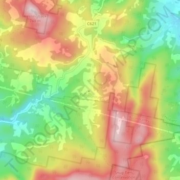
Name: Kaoota topographic map, elevation, terrain.

Location: Kaoota, Hobart, Kingborough, Tasmania, 7150, Australia (-43.06063 147.13076 -43.00356 147.18829)

Average elevation: 1,375 ft

Minimum elevation: 466 ft

Maximum elevation: 2,408 ft

Other topographic maps

Click on a map to view its topography, its elevation and its terrain.

Selfs Point

Australia > Tasmania > Hobart

Average elevation: 56 ft

Waterworks Reserve

Australia > Tasmania > Hobart

Average elevation: 787 ft

James Austin Park

Australia > Tasmania > Hobart

Average elevation: 82 ft

Perrins Ridge

Australia > Tasmania > Hobart

Average elevation: 1,532 ft

Cartwright Point

Australia > Tasmania > Hobart

Average elevation: 194 ft

Mount Direction

Australia > Tasmania > Hobart

Average elevation: 545 ft

Glebe Hill

Australia > Tasmania > Hobart

Average elevation: 217 ft

Knocklofty

Australia > Tasmania > Hobart

Average elevation: 607 ft

Snug Falls

Australia > Tasmania > Hobart > Snug

Average elevation: 1,102 ft

Tolosa Park

Australia > Tasmania > Hobart

Average elevation: 597 ft

Glenrose Park

Australia > Tasmania > Hobart

Average elevation: 594 ft

Gear up for your next adventure:

🧥Men's Rain Shells - Premium waterproof and breathable jackets for mountain weather
🥾Women's Hiking Boots - Top-rated trail boots with ankle support and superior grip
🪑Portable Camp Table - Compact table for campsite meals
🔊Portable Camp Speaker - Music and alerts at camp
🌎3D Topographic Globes - Raised relief globes for a tactile understanding of geography

As an Amazon Associate, this site earns from qualifying purchases at no extra cost to you.