
Make a donation
Gear up for your next adventure:
As an Amazon Associate, this site earns from qualifying purchases at no extra cost to you.
Saint-Gilles topographic map
Click on the map to display elevation.
Make a donation
Gear up for your next adventure:
As an Amazon Associate, this site earns from qualifying purchases at no extra cost to you.
About this map
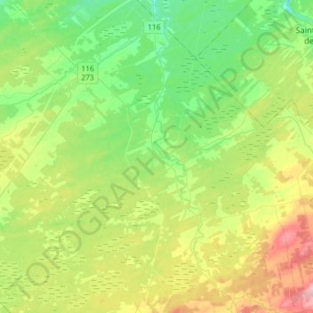
Name: Saint-Gilles topographic map, elevation, terrain.
Average elevation: 456 ft
Minimum elevation: 318 ft
Maximum elevation: 715 ft
Make a donation
Gear up for your next adventure:
As an Amazon Associate, this site earns from qualifying purchases at no extra cost to you.
Other topographic maps
Click on a map to view its topography, its elevation and its terrain.
Saint-Antoine de Tilly
Canada > Québec > Lotbinière (MRC) > Saint-Antoine-de-Tilly
Average elevation: 105 ft
Mont Sainte-Marguerite
Canada > Québec > Lotbinière (MRC) > Saint-Sylvestre
Average elevation: 1,745 ft
Ruisseau Sainte-Croix
Canada > Québec > Lotbinière (MRC) > Sainte-Agathe-de-Lotbinière
Average elevation: 748 ft
Make a donation
Gear up for your next adventure:
As an Amazon Associate, this site earns from qualifying purchases at no extra cost to you.
Rivière Saint-Georges
Canada > Québec > Lotbinière (MRC) > Sainte-Agathe-de-Lotbinière
Average elevation: 518 ft
Saint-Antoine de Tilly
Canada > Québec > Lotbinière (MRC) > Saint-Antoine-de-Tilly
Average elevation: 105 ft