Geolocate

Érd topographic map

Click on the map to display elevation.

About this map

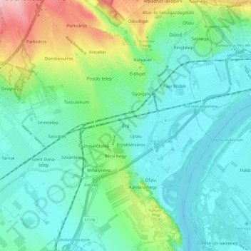
Name: Érd topographic map, elevation, terrain.

Location: Érd, Érdi járás, Pest, Central Hungary, 2030, Hungary (47.33725 18.88138 47.41725 18.96138)

Average elevation: 436 ft

Minimum elevation: 305 ft

Maximum elevation: 840 ft

Gear up for your next adventure:

🪵Folding Camp Saw - Compact saw for wood and campsite work
📷Action Camera - Capture your outdoor adventures in HD
📦Gear Storage Bags - Organize and protect outdoor equipment
🦶Hiking Gaiters - Keep debris and water out of your boots
🍳Camping Cook Set - Complete cookware for outdoor meals

As an Amazon Associate, this site earns from qualifying purchases at no extra cost to you.