
Make a donation
Gear up for your next adventure:
As an Amazon Associate, this site earns from qualifying purchases at no extra cost to you.
Castellbisbal topographic map
Click on the map to display elevation.
Make a donation
Gear up for your next adventure:
As an Amazon Associate, this site earns from qualifying purchases at no extra cost to you.
Castellbisbal
El relieve del municipio está caracterizado por el valle del río Llobregat por el sur y por una zona más montañosa con torrentes y rieras por el norte que supera los 200 metros de altitud. La altitud oscila entre los 267 metros al norte y los 40 metros a orillas del río Llobregat. El pueblo se alza a 152 metros sobre el nivel del mar.
Make a donation
Gear up for your next adventure:
As an Amazon Associate, this site earns from qualifying purchases at no extra cost to you.
About this map
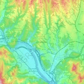
Name: Castellbisbal topographic map, elevation, terrain.
Average elevation: 430 ft
Minimum elevation: 82 ft
Maximum elevation: 1,152 ft
Make a donation
Gear up for your next adventure:
As an Amazon Associate, this site earns from qualifying purchases at no extra cost to you.