
Make a donation
Gear up for your next adventure:
As an Amazon Associate, this site earns from qualifying purchases at no extra cost to you.
Cañon City topographic map
Click on the map to display elevation.
Make a donation
Gear up for your next adventure:
As an Amazon Associate, this site earns from qualifying purchases at no extra cost to you.
Cañon City
The city's nickname, "the Climate Capital of Colorado", derives from the combination of unique geography and 5,300-foot (1,600 m) elevation protecting the city from harsh weather conditions. The average daily high temperature in January is 14 °F (7.8 °C) warmer in Cañon City than in Grand Junction, even though the elevation of Cañon City is higher.
Make a donation
Gear up for your next adventure:
As an Amazon Associate, this site earns from qualifying purchases at no extra cost to you.
About this map
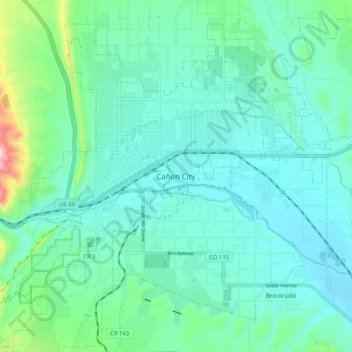
Name: Cañon City topographic map, elevation, terrain.
Location: Cañon City, Fremont County, Colorado, 81212, United States (38.40236 -105.26249 38.48236 -105.18249)
Average elevation: 5,479 ft
Minimum elevation: 5,213 ft
Maximum elevation: 6,709 ft
Fremont County trails, hiking, mountain biking, running and outdoor activities
Make a donation
Gear up for your next adventure:
As an Amazon Associate, this site earns from qualifying purchases at no extra cost to you.