
Make a donation
Gear up for your next adventure:
As an Amazon Associate, this site earns from qualifying purchases at no extra cost to you.
Neder-Over-Heembeek topographic map
Click on the map to display elevation.
Make a donation
Gear up for your next adventure:
As an Amazon Associate, this site earns from qualifying purchases at no extra cost to you.
Neder-Over-Heembeek
Neder-Over-Heembeek ligt in de vallei van de Zenne op een hoogte van 18-68 meter. Ook loopt hier het Kanaal Brussel-Schelde. De plaats is sterk verstedelijkt. Een belangrijk natuurgebied is het Begijnenbosdal ten noorden van de plaats.
Make a donation
Gear up for your next adventure:
As an Amazon Associate, this site earns from qualifying purchases at no extra cost to you.
About this map
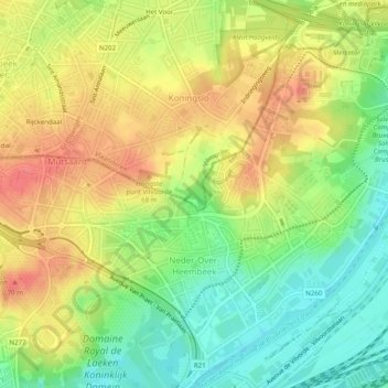
Name: Neder-Over-Heembeek topographic map, elevation, terrain.
Average elevation: 138 ft
Minimum elevation: 26 ft
Maximum elevation: 249 ft
Make a donation
Gear up for your next adventure:
As an Amazon Associate, this site earns from qualifying purchases at no extra cost to you.
Other topographic maps
Click on a map to view its topography, its elevation and its terrain.
Warandepark
België > Brussel-Hoofdstad > Brussel
Het symmetrische ontwerp van de van oorsprong Franse architect Barnabé Guimard, bijgestaan voor wat de aanleg van het park betreft door de Oostenrijkse landschapsarchitect en inspecteur van het Zoniënwoud Joachim Zinner, en in Parijs ter goedkeuring de daar residerende architect Nicolas Barré voorgelegd,…
Average elevation: 174 ft
Make a donation
Gear up for your next adventure:
As an Amazon Associate, this site earns from qualifying purchases at no extra cost to you.