
Make a donation
Gear up for your next adventure:
As an Amazon Associate, this site earns from qualifying purchases at no extra cost to you.
Hamby Mountain topographic map
Click on the map to display elevation.
Make a donation
Gear up for your next adventure:
As an Amazon Associate, this site earns from qualifying purchases at no extra cost to you.
About this map
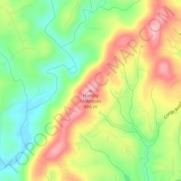
Name: Hamby Mountain topographic map, elevation, terrain.
Location: Hamby Mountain, Wilkes County, North Carolina, United States (36.16064 -81.28264 36.16074 -81.28254)
Average elevation: 1,306 ft
Minimum elevation: 1,066 ft
Maximum elevation: 1,578 ft
Wilkes County trails, hiking, mountain biking, running and outdoor activities
Make a donation
Gear up for your next adventure:
As an Amazon Associate, this site earns from qualifying purchases at no extra cost to you.
Other topographic maps
Click on a map to view its topography, its elevation and its terrain.
Rendezvous Mountain State Park
United States > North Carolina > Wilkes County
Average elevation: 1,775 ft
Make a donation
Gear up for your next adventure:
As an Amazon Associate, this site earns from qualifying purchases at no extra cost to you.
Make a donation
Gear up for your next adventure:
As an Amazon Associate, this site earns from qualifying purchases at no extra cost to you.
Moravian Creek
United States > North Carolina > Wilkes County > Wilkesboro
Average elevation: 1,037 ft