Geolocate

Naibuan topographic map

Click on the map to display elevation.

About this map

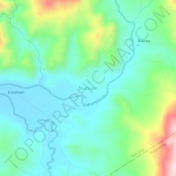
Name: Naibuan topographic map, elevation, terrain.

Location: Naibuan, San Jose, Occidental Mindoro, Mimaropa, Philippines (12.46905 121.16119 12.50905 121.20119)

Average elevation: 604 ft

Minimum elevation: 220 ft

Maximum elevation: 1,703 ft

Other topographic maps

Click on a map to view its topography, its elevation and its terrain.

Barangay 4

Philippines > Occidental Mindoro > San Jose

Average elevation: 10 ft

Labangan

Philippines > Occidental Mindoro > San Jose > Mabini

Average elevation: 13 ft

Barangay 5

Philippines > Occidental Mindoro > San Jose

Average elevation: 10 ft

Bagong Sikat

Philippines > Occidental Mindoro > San Jose

Average elevation: 20 ft

Gear up for your next adventure:

🧦Hiking Socks - Comfortable socks to prevent blisters on long hikes
🛡️Insect Repellent - Protection against bugs during outdoor activities
🪶Trail Camera - Capture wildlife on your hikes
🔥Plasma Lighters - Windproof lighters that work in any weather condition
📶Vehicle Signal Boosters - Improve reception in rural areas while driving to trailheads

As an Amazon Associate, this site earns from qualifying purchases at no extra cost to you.