Geolocate

Leshten topographic map

Click on the map to display elevation.

About this map

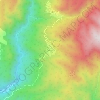
Name: Leshten topographic map, elevation, terrain.

Location: Leshten, Garmen, Blagoevgrad, 2962, Bulgaria (41.61691 23.80783 41.65691 23.84783)

Average elevation: 3,153 ft

Minimum elevation: 1,923 ft

Maximum elevation: 4,544 ft

Other topographic maps

Click on a map to view its topography, its elevation and its terrain.

Рупите

Bulgaria > Blagoevgrad

Average elevation: 384 ft

Тевно езеро

Bulgaria > Blagoevgrad

Average elevation: 7,969 ft

Frog lake

Bulgaria > Blagoevgrad

Average elevation: 7,907 ft

Gear up for your next adventure:

📷Action Camera - Capture your outdoor adventures in HD
🧴Hand Sanitizer - Keep hands clean while hiking
🦺Reflective Outdoor Gear - Safety gear for low‑light conditions
🔦LED Headlamp - Bright and durable LED headlamp for night navigation
📌Outdoor GPS Map App - Apps and devices for digital topographic navigation

As an Amazon Associate, this site earns from qualifying purchases at no extra cost to you.