Geolocate

Razlog topographic map

Click on the map to display elevation.

About this map

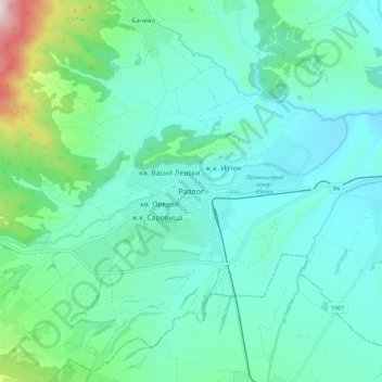
Name: Razlog topographic map, elevation, terrain.

Location: Razlog, Blagoevgrad, 2760, Bulgaria (41.84611 23.42615 41.92611 23.50615)

Average elevation: 2,920 ft

Minimum elevation: 2,536 ft

Maximum elevation: 4,636 ft

Other topographic maps

Click on a map to view its topography, its elevation and its terrain.

Рупите

Bulgaria > Blagoevgrad

Average elevation: 384 ft

Тевно езеро

Bulgaria > Blagoevgrad

Average elevation: 7,969 ft

Frog lake

Bulgaria > Blagoevgrad

Average elevation: 7,907 ft

Gear up for your next adventure:

Backpacking Tents - Weight-optimized shelters for multi-day topographic surveys
🧥Men's Rain Shells - Premium waterproof and breathable jackets for mountain weather
📡GPS Antenna Upgrade - Enhance GPS reception in remote terrain
Camping Coffee Makers - Enjoy premium coffee at the summit or campsite
🥘Titanium Cookware - Durable, featherlight pots and pans for backpacking

As an Amazon Associate, this site earns from qualifying purchases at no extra cost to you.