
Make a donation
Gear up for your next adventure:
As an Amazon Associate, this site earns from qualifying purchases at no extra cost to you.
Gołdap County topographic map
Click on the map to display elevation.
Make a donation
Gear up for your next adventure:
As an Amazon Associate, this site earns from qualifying purchases at no extra cost to you.
About this map
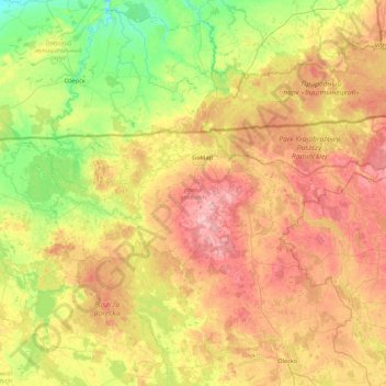
Name: Gołdap County topographic map, elevation, terrain.
Location: Gołdap County, Warmian-Masurian Voivodeship, Poland (54.15760 21.93800 54.36378 22.80614)
Average elevation: 505 ft
Minimum elevation: 157 ft
Maximum elevation: 991 ft
Make a donation
Gear up for your next adventure:
As an Amazon Associate, this site earns from qualifying purchases at no extra cost to you.
Other topographic maps
Click on a map to view its topography, its elevation and its terrain.
Majewo-Kolonia
Poland > Warmian-Masurian Voivodeship > Elbląg County > Majewo
Average elevation: 466 ft
Make a donation
Gear up for your next adventure:
As an Amazon Associate, this site earns from qualifying purchases at no extra cost to you.
Make a donation
Gear up for your next adventure:
As an Amazon Associate, this site earns from qualifying purchases at no extra cost to you.
Mrozy Małe
Poland > Warmian-Masurian Voivodeship > Ełk County > Mrozy Wielkie > Mrozy Małe
Average elevation: 417 ft