Geolocate

Ratzing topographic map

Click on the map to display elevation.

About this map

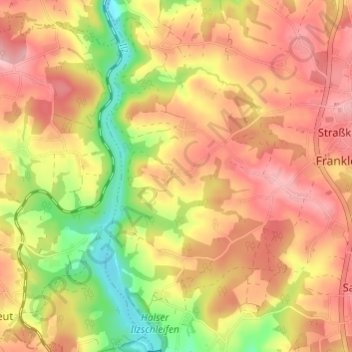
Name: Ratzing topographic map, elevation, terrain.

Location: Ratzing, Salzweg, Landkreis Passau, Bayern, 94121, Deutschland (48.60776 13.42905 48.64776 13.46905)

Average elevation: 1,316 ft

Minimum elevation: 1,030 ft

Maximum elevation: 1,512 ft

Gear up for your next adventure:

🧥Waterproof Jacket for Hiking - Breathable and rugged rain jacket for outdoor excursions
🛰️Satellite Messengers - Emergency SOS and two-way messaging for off-grid adventures
🥩Freeze-Dried Meals - Nutritious and lightweight food for remote expeditions
🔋Solar Power Banks - Keep your GPS and phone charged in remote wilderness areas
📶Satellite Messenger - Communication device off‑grid

As an Amazon Associate, this site earns from qualifying purchases at no extra cost to you.