Geolocate

Hub topographic map

Click on the map to display elevation.

About this map

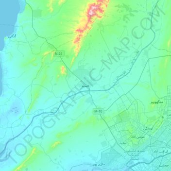
Name: Hub topographic map, elevation, terrain.

Location: Hub, Lasbela District, Balochistan, 90250, Pakistan (24.86554 66.72403 25.18554 67.04403)

Average elevation: 180 ft

Minimum elevation: -7 ft

Maximum elevation: 1,680 ft

Gear up for your next adventure:

📦Gear Storage Bags - Organize and protect outdoor equipment
🔋Solar Power Banks - Keep your GPS and phone charged in remote wilderness areas
🦶Carbon Trekking Poles - Reduce knee impact on steep descents with ultra-light poles
🪄Magnetic Compass - Accurate compass for navigation
🧭GPS Watch Accessories - Bands and chargers for GPS watches

As an Amazon Associate, this site earns from qualifying purchases at no extra cost to you.