
Thank you for supporting this site ❤️
Make a donation
Make a donation
Gear up for your next adventure:
As an Amazon Associate, this site earns from qualifying purchases at no extra cost to you.
Mais topographic map
Click on the map to display elevation.
Thank you for supporting this site ❤️
Make a donation
Make a donation
Gear up for your next adventure:
As an Amazon Associate, this site earns from qualifying purchases at no extra cost to you.
About this map
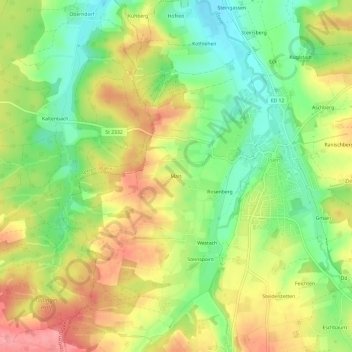
Name: Mais topographic map, elevation, terrain.
Location: Mais, Isen, Landkreis Erding, Baviera, 84424, Alemanha (48.19020 12.02040 48.23020 12.06040)
Average elevation: 1,749 ft
Minimum elevation: 1,591 ft
Maximum elevation: 1,919 ft
Thank you for supporting this site ❤️
Make a donation
Make a donation
Gear up for your next adventure:
As an Amazon Associate, this site earns from qualifying purchases at no extra cost to you.