Lone Pine topographic map
Click on the map to display elevation.
About this map

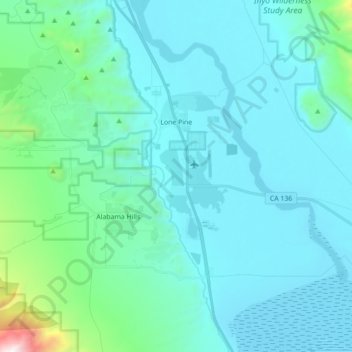
Name: Lone Pine topographic map, elevation, terrain.
Location: Lone Pine, Inyo County, California, United States (36.51271 -118.11607 36.65366 -118.04103)
Average elevation: 4,259 ft
Minimum elevation: 3,556 ft
Maximum elevation: 9,688 ft
Lone Pine is a census-designated place (CDP) in Inyo County, California, United States. Lone Pine is located 16 mi (26 km) south-southeast of Independence, at an elevation of 3,727 ft (1,136 m). The population was 2,035 at the 2010 census, up from 1,655 at the 2000 census. The town is located in the Owens Valley, near the Alabama Hills and Mount Whitney, between the eastern peaks of the Sierra Nevada to the west and the Inyo Mountains to the east. The local hospital, Southern Inyo Hospital, offers standby emergency services. The town is named after a solitary pine tree that once existed at the mouth of Lone Pine Canyon. On March 26, 1872, the very large Lone Pine earthquake destroyed most of the town and killed 27 of its 250 to 300 residents.
Other topographic maps
Click on a map to view its topography, its elevation and its terrain.

Bishop
United States > California > Inyo County
Bishop, Inyo County, California, United States
Average elevation: 4,150 ft

Gem Lakes
United States > California > Inyo County
Gem Lakes, Inyo County, California, United States
Average elevation: 11,421 ft

Mount Whitney
United States > California > Inyo County
Mount Whitney, Inyo County, CAL Fire Southern Region, California, United States
Average elevation: 12,805 ft

Independence
United States > California > Inyo County
Independence, Inyo County, CAL Fire Southern Region, California, 93526, United States
Average elevation: 3,970 ft

Kearsarge
United States > California > Inyo County
Kearsarge, Inyo County, California, United States
Average elevation: 3,802 ft

Aspendell
United States > California > Inyo County
Aspendell, Inyo County, California, United States
Average elevation: 9,288 ft

Upper Lamarck Lake
United States > California > Inyo County
Upper Lamarck Lake, Inyo County, California, United States
Average elevation: 11,342 ft

Mount Perry
United States > California > Inyo County
Mount Perry, Inyo County, California, United States
Average elevation: 4,334 ft

Mount LeConte
United States > California > Inyo County
Mount LeConte, Inyo County, CAL Fire Southern Region, California, United States
Average elevation: 12,431 ft

Little Lake
United States > California > Inyo County
Little Lake, Inyo County, California, United States
Average elevation: 3,563 ft

West Bishop
United States > California > Inyo County > Rocking K
West Bishop, Rocking K, Inyo County, CAL Fire Southern Region, California, United States
Average elevation: 4,859 ft

Wildrose Peak
United States > California > Inyo County
Wildrose Peak, Inyo County, California, United States
Average elevation: 7,881 ft

Sandy Valley
United States > California > Inyo County
Sandy Valley, Inyo County, California, United States
Average elevation: 2,648 ft

Owens Valley
United States > California > Inyo County
Owens Valley, Inyo County, CAL Fire Southern Region, California, United States
Average elevation: 6,857 ft

Tin Mountain
United States > California > Inyo County
Tin Mountain, Inyo County, California, United States
Average elevation: 7,835 ft

Olancha
United States > California > Inyo County
Olancha, Inyo County, CAL Fire Southern Region, California, United States
Average elevation: 3,934 ft