
Thank you for supporting this site ❤️
Make a donation
Make a donation
Gear up for your next adventure:
As an Amazon Associate, this site earns from qualifying purchases at no extra cost to you.
Butarrón topographic map
Click on the map to display elevation.
Thank you for supporting this site ❤️
Make a donation
Make a donation
Gear up for your next adventure:
As an Amazon Associate, this site earns from qualifying purchases at no extra cost to you.
About this map
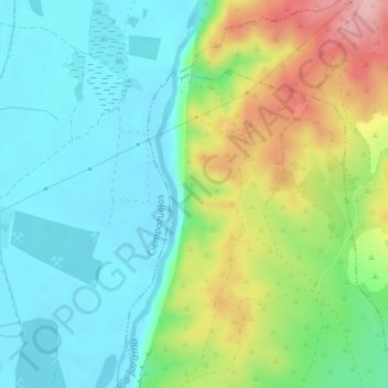
Name: Butarrón topographic map, elevation, terrain.
Location: Butarrón, Titulcia, Las Vegas, Comunidad de Madrid, España (40.15261 -3.57001 40.17261 -3.55001)
Average elevation: 1,798 ft
Minimum elevation: 1,634 ft
Maximum elevation: 2,142 ft
Thank you for supporting this site ❤️
Make a donation
Make a donation
Gear up for your next adventure:
As an Amazon Associate, this site earns from qualifying purchases at no extra cost to you.