Geolocate

Johns Lake topographic map

Click on the map to display elevation.

About this map

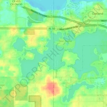
Name: Johns Lake topographic map, elevation, terrain.

Location: Johns Lake, Clermont, Lake County, Florida, United States (28.51653 -81.68527 28.54688 -81.61400)

Average elevation: 115 ft

Minimum elevation: 49 ft

Maximum elevation: 230 ft

Lake County trails, hiking, mountain biking, running and outdoor activities

Gear up for your next adventure:

🕶️Glacier Sunglasses - Side shields to protect eyes from high-altitude snow glare
🛰️Handheld GPS Units - Professional satellite navigators for precise backcountry mapping
🚁Photography Drones - Capture stunning aerial views of landforms and topography
🛶Inflatable Kayak - Portable kayak for rivers, lakes, and expeditions
🕶️GPS Smartphone Mount - Secure mount for phone navigation

As an Amazon Associate, this site earns from qualifying purchases at no extra cost to you.