
Thank you for supporting this site ❤️
Make a donation
Make a donation
Gear up for your next adventure:
As an Amazon Associate, this site earns from qualifying purchases at no extra cost to you.
Wahlstedt topographic map
Click on the map to display elevation.
Thank you for supporting this site ❤️
Make a donation
Make a donation
Gear up for your next adventure:
As an Amazon Associate, this site earns from qualifying purchases at no extra cost to you.
About this map
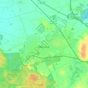
Name: Wahlstedt topographic map, elevation, terrain.
Location: Wahlstedt, Kreis Segeberg, Schleswig-Holstein, 23812, Germany (53.93343 10.15133 53.97394 10.23831)
Average elevation: 144 ft
Minimum elevation: 102 ft
Maximum elevation: 223 ft
Thank you for supporting this site ❤️
Make a donation
Make a donation
Gear up for your next adventure:
As an Amazon Associate, this site earns from qualifying purchases at no extra cost to you.
Other topographic maps
Click on a map to view its topography, its elevation and its terrain.
Strand Seekamp
Germany > Schleswig-Holstein > Kreis Segeberg > Berlin > Seekamp
Average elevation: 125 ft