Geolocate

Duhatan topographic map

Click on the map to display elevation.

About this map

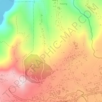
Name: Duhatan topographic map, elevation, terrain.

Location: Duhatan, Lipa, Batangas, Calabarzon, 4217, Philippines (13.92435 121.06920 13.95071 121.09399)

Average elevation: 978 ft

Minimum elevation: -56 ft

Maximum elevation: 1,637 ft

Other topographic maps

Click on a map to view its topography, its elevation and its terrain.

Bulacnin

Philippines > Batangas > Lipa

Average elevation: 1,053 ft

Amiya Rosa Phase 1

Philippines > Batangas > Lipa

Average elevation: 1,017 ft

Pusil

Philippines > Batangas > Lipa

Average elevation: 1,106 ft

Mount Malepunyo

Philippines > Batangas > Lipa

Average elevation: 2,283 ft

Santo Toribio

Philippines > Batangas > Lipa

Average elevation: 673 ft

Gear up for your next adventure:

🥾Women's Hiking Boots - Top-rated trail boots with ankle support and superior grip
🩳Quick‑Dry Hiking Shorts - Comfortable and quick‑dry shorts for summer hiking
🔊Portable Camp Speaker - Music and alerts at camp
🧯Portable Fire Pit - Compact fire pit for camping spots
📚USA Hiking Guide Books - Top trail guides and map books

As an Amazon Associate, this site earns from qualifying purchases at no extra cost to you.