
Make a donation
Gear up for your next adventure:
As an Amazon Associate, this site earns from qualifying purchases at no extra cost to you.
Arandon topographic map
Click on the map to display elevation.
Make a donation
Gear up for your next adventure:
As an Amazon Associate, this site earns from qualifying purchases at no extra cost to you.
About this map
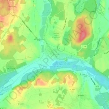
Name: Arandon topographic map, elevation, terrain.
Average elevation: 791 ft
Minimum elevation: 682 ft
Maximum elevation: 942 ft
Make a donation
Gear up for your next adventure:
As an Amazon Associate, this site earns from qualifying purchases at no extra cost to you.
Other topographic maps
Click on a map to view its topography, its elevation and its terrain.
Passins
France > Auvergne-Rhône-Alpes > Isère > Arandon-Passins
Passins se trouve approximativement à une altitude de 290 mètres et une superficie de 13,92 km2. Les coordonnées de ce village sont, 45,688 degrés Nord et 5,43 degrés Est.
Average elevation: 863 ft