
Make a donation
Gear up for your next adventure:
As an Amazon Associate, this site earns from qualifying purchases at no extra cost to you.
Saboti topographic map
Click on the map to display elevation.
Make a donation
Gear up for your next adventure:
As an Amazon Associate, this site earns from qualifying purchases at no extra cost to you.
About this map
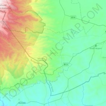
Name: Saboti topographic map, elevation, terrain.
Location: Saboti, Trans-Nzoia County, Rift Valley, 30200, Kenya (0.85234 34.67854 1.04301 35.02693)
Average elevation: 6,657 ft
Minimum elevation: 5,200 ft
Maximum elevation: 11,437 ft
Make a donation
Gear up for your next adventure:
As an Amazon Associate, this site earns from qualifying purchases at no extra cost to you.
Other topographic maps
Click on a map to view its topography, its elevation and its terrain.
Kitale
Kenya > Trans-Nzoia County > Saboti
Kitale is a town in the north west of Kenya, in the old Rift Valley province. It situated between Mount Elgon and the Cherangany Hills. The town has an elevation of around 1,900 metres (6,200 ft). Its population was 162,174 as of 2019. Kitale town is the headquarter of the Trans-Nzoia County, which is also…
Average elevation: 6,066 ft
Kitale
Kenya > Trans-Nzoia County > Saboti
Kitale is an agricultural town in northern Rift Valley Kenya situated between Mount Elgon and the Cherangany Hills at an elevation of around 1,900 metres (6,200 ft). Its population is 106,187 as of 2009. Kitale is the headquarter town of Trans-Nzoia County. Kitale is reachable by air through Kitale Airport.…
Average elevation: 6,066 ft