
Make a donation
Gear up for your next adventure:
As an Amazon Associate, this site earns from qualifying purchases at no extra cost to you.
Plage d'Agay topographic map
Click on the map to display elevation.
Make a donation
Gear up for your next adventure:
As an Amazon Associate, this site earns from qualifying purchases at no extra cost to you.
About this map
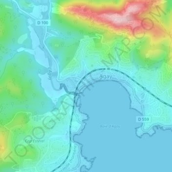
Name: Plage d'Agay topographic map, elevation, terrain.
Average elevation: 177 ft
Minimum elevation: -3 ft
Maximum elevation: 876 ft
Make a donation
Gear up for your next adventure:
As an Amazon Associate, this site earns from qualifying purchases at no extra cost to you.
Other topographic maps
Click on a map to view its topography, its elevation and its terrain.
Pointe de l’Observatoire
France > Provence-Alpes-Côte d'Azur > Var > Saint-Raphaël
Average elevation: 171 ft
Make a donation
Gear up for your next adventure:
As an Amazon Associate, this site earns from qualifying purchases at no extra cost to you.
Grotte Saint-Barthélemy
France > Provence-Alpes-Côte d'Azur > Var > Saint-Raphaël
Average elevation: 305 ft
Pointe de l’Observatoire
France > Provence-Alpes-Côte d'Azur > Var > Saint-Raphaël
Average elevation: 171 ft