
Make a donation
Gear up for your next adventure:
As an Amazon Associate, this site earns from qualifying purchases at no extra cost to you.
Olsztyn topographic map
Click on the map to display elevation.
Make a donation
Gear up for your next adventure:
As an Amazon Associate, this site earns from qualifying purchases at no extra cost to you.
About this map
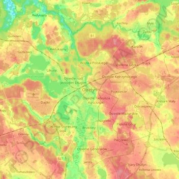
Name: Olsztyn topographic map, elevation, terrain.
Location: Olsztyn, Warmian-Masurian Voivodeship, Poland (53.72421 20.36649 53.82902 20.56665)
Average elevation: 404 ft
Minimum elevation: 256 ft
Maximum elevation: 515 ft
Make a donation
Gear up for your next adventure:
As an Amazon Associate, this site earns from qualifying purchases at no extra cost to you.
Other topographic maps
Click on a map to view its topography, its elevation and its terrain.
Majewo-Kolonia
Poland > Warmian-Masurian Voivodeship > Elbląg County > Majewo
Average elevation: 466 ft
Make a donation
Gear up for your next adventure:
As an Amazon Associate, this site earns from qualifying purchases at no extra cost to you.
Make a donation
Gear up for your next adventure:
As an Amazon Associate, this site earns from qualifying purchases at no extra cost to you.
Mrozy Małe
Poland > Warmian-Masurian Voivodeship > Ełk County > Mrozy Wielkie > Mrozy Małe
Average elevation: 417 ft