Geolocate

Alipanta topographic map

Click on the map to display elevation.

About this map

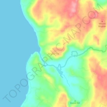
Name: Alipanta topographic map, elevation, terrain.

Location: Alipanta, Pangasinan, Ilocos Region, Philippines (16.06429 119.75493 16.10429 119.79493)

Average elevation: 131 ft

Minimum elevation: 0 ft

Maximum elevation: 367 ft

Other topographic maps

Click on a map to view its topography, its elevation and its terrain.

Infanta

Philippines > Pangasinan

Average elevation: 223 ft

Bugallon

Philippines > Pangasinan

Average elevation: 643 ft

Sinocalan River

Philippines > Pangasinan > Santa Barbara

Average elevation: 20 ft

Sinocalan River

Philippines > Pangasinan > San Manuel

Average elevation: 1,161 ft

Labrador

Philippines > Pangasinan

Average elevation: 148 ft

Lasud River

Philippines > Pangasinan > Abagatanen

Average elevation: 308 ft

Santiago Island

Philippines > Pangasinan > Bolinao

Average elevation: 30 ft

San Carlos

Philippines > Pangasinan

Average elevation: 26 ft

Malasiqui

Philippines > Pangasinan > Malasiqui

Average elevation: 66 ft

San Roque Dam

Philippines > Pangasinan

Average elevation: 748 ft

Siapar Island

Philippines > Pangasinan

Average elevation: 7 ft

Gear up for your next adventure:

Backpacking Tent - Lightweight and durable tent for multi‑day hikes
📷Action Cameras - Rugged cameras to document your journeys across rugged terrain
🛡️Insect Repellent - Protection against bugs during outdoor activities
🛏️Cold Weather Sleeping Bag - Warm sleeping bag for cold conditions
🪶Survival Guide Book - Expert advice for emergency preparedness

As an Amazon Associate, this site earns from qualifying purchases at no extra cost to you.