
Make a donation
Gear up for your next adventure:
As an Amazon Associate, this site earns from qualifying purchases at no extra cost to you.
Greifenhain topographic map
Click on the map to display elevation.
Make a donation
Gear up for your next adventure:
As an Amazon Associate, this site earns from qualifying purchases at no extra cost to you.
About this map
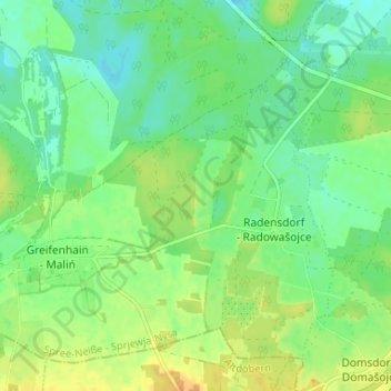
Name: Greifenhain topographic map, elevation, terrain.
Location: Greifenhain, Drebkau, Spree-Neiße, Brandenburg, Deutschland (51.63598 14.12016 51.67078 14.18557)
Average elevation: 295 ft
Minimum elevation: 256 ft
Maximum elevation: 351 ft
Make a donation
Gear up for your next adventure:
As an Amazon Associate, this site earns from qualifying purchases at no extra cost to you.
Other topographic maps
Click on a map to view its topography, its elevation and its terrain.
Raakow
Deutschland > Brandenburg > Spree-Neiße > Drebkau
Hans Siegmund von Köckritz starb 1668 und hinterließ vier Söhne: Siegmund Adolf, Siegmund Seyfried, Kaspar Siegmund und Kaspar Friedrich. Sie erhielten am 15. Januar 1670 den Lehnbrief über Raakow und halb Laubst. Nach Gerhard Krüger kaufte Siegmund Adolf Raakow aus der Konkursmasse seines Vaters für…
Average elevation: 328 ft
Make a donation
Gear up for your next adventure:
As an Amazon Associate, this site earns from qualifying purchases at no extra cost to you.
Jehserig
Deutschland > Brandenburg > Spree-Neiße > Drebkau
Jehserig liegt unweit des ursprünglichen Drebkauer Stadtgebiets und jeweils 12 km entfernt von Cottbus und Spremberg. Der Ort liegt am Rande des durch die Elstereiszeit aufgeschobenen Höhenzuges „Steinitzer Alpen“ und hat eine Höhe ü. M. von 97 m (Merkur) bis 136 m (Papproth). Mit 158 m ist der…
Average elevation: 381 ft