
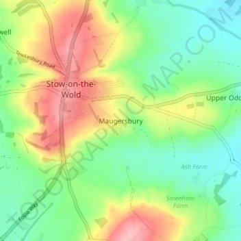
Maugersbury topographic map
Interactive map
Click on the map to display elevation.
About this map
Name: Maugersbury topographic map, elevation, terrain.
Average elevation: 545 ft
Minimum elevation: 377 ft
Maximum elevation: 801 ft
Other topographic maps
Click on a map to view its topography, its elevation and its terrain.
Condicote
United Kingdom > England > Gloucestershire > Cotswold District
Condicote, Cotswold District, Gloucestershire, England, GL54 1ES, United Kingdom
Average elevation: 659 ft
Lower Slaughter
United Kingdom > England > Gloucestershire > Cotswold District
Lower Slaughter, Cotswold District, Gloucestershire, England, GL54 2HX, United Kingdom
Average elevation: 525 ft
Cutsdean
United Kingdom > England > Gloucestershire > Cotswold District
Cutsdean, Cotswold District, Gloucestershire, England, United Kingdom
Average elevation: 764 ft
Dowdeswell
United Kingdom > England > Gloucestershire > Cotswold District
Dowdeswell, Cotswold District, Gloucestershire, England, United Kingdom
Average elevation: 686 ft
Daylesford
United Kingdom > England > Gloucestershire > Cotswold District
Daylesford, Cotswold District, Gloucestershire, England, GL56 0YG, United Kingdom
Average elevation: 449 ft
Barnsley
United Kingdom > England > Gloucestershire > Cotswold District
Barnsley, Cotswold District, Gloucestershire, England, GL7 5EF, United Kingdom
Average elevation: 443 ft
Duntisbourne Abbots
United Kingdom > England > Gloucestershire > Cotswold District
Duntisbourne Abbots, Cotswold District, Gloucestershire, England, GL7 7JN, United Kingdom
Average elevation: 669 ft
Tarlton
United Kingdom > England > Gloucestershire > Cotswold District
Tarlton, Rodmarton, Cotswold District, Gloucestershire, England, GL7 6PA, United Kingdom
Average elevation: 472 ft
Bagpath
United Kingdom > England > Gloucestershire > Cotswold District
Bagpath, Kingscote, Cotswold District, Gloucestershire, England, GL8 8YG, United Kingdom
Average elevation: 650 ft
Cerney Wick
United Kingdom > England > Gloucestershire > Cotswold District
Cerney Wick, Cotswold District, Gloucestershire, England, GL7 5QH, United Kingdom
Average elevation: 279 ft
Birdlip
United Kingdom > England > Gloucestershire > Cotswold District
Birdlip, Cotswold District, Gloucestershire, England, United Kingdom
Average elevation: 856 ft
Worcestershire (detached)
United Kingdom > England > Gloucestershire > Cotswold District
Worcestershire (detached), Cotswold District, Gloucestershire, West Midlands Combined Authority, England, United Kingdom
Average elevation: 338 ft
Syde
United Kingdom > England > Gloucestershire > Cotswold District
Syde, Cotswold District, Gloucestershire, England, GL53 9PN, United Kingdom
Average elevation: 781 ft
Cirencester
United Kingdom > England > Gloucestershire > Cotswold District > Chesterton
Cirencester, Chesterton, Cotswold District, Gloucestershire, England, United Kingdom
Average elevation: 420 ft
Mickleton
United Kingdom > England > Gloucestershire > Cotswold District
Mickleton, Cotswold District, Gloucestershire, England, GL55 6TS, United Kingdom
Average elevation: 331 ft
Taylors Hill
United Kingdom > England > Gloucestershire > Cotswold District
Taylors Hill, Cotswold District, Gloucestershire, England, GL54 4BJ, United Kingdom
Average elevation: 778 ft
Trewsbury Mead
United Kingdom > England > Gloucestershire > Cotswold District
Trewsbury Mead, Coates, Cotswold District, Gloucestershire, England, GL7 6NY, United Kingdom
Average elevation: 400 ft
North Cerney
United Kingdom > England > Gloucestershire > Cotswold District
North Cerney, Cotswold District, Gloucestershire, England, GL7 7BZ, United Kingdom
Average elevation: 587 ft
Hatherop
United Kingdom > England > Gloucestershire > Cotswold District
Hatherop, Cotswold District, Gloucestershire, England, GL7 3NA, United Kingdom
Average elevation: 394 ft
Stow-on-the-Wold
United Kingdom > England > Gloucestershire > Cotswold District
Stow-on-the-Wold, Cotswold District, Gloucestershire, England, GL54 1AB, United Kingdom
Average elevation: 535 ft
Botany Bay Wood
United Kingdom > England > Gloucestershire > Cotswold District > Stow-on-the-Wold
Botany Bay Wood, Maugersbury, Stow-on-the-Wold, Cotswold District, Gloucestershire, England, United Kingdom
Average elevation: 561 ft
Eastleach Martin
United Kingdom > England > Gloucestershire > Cotswold District > Eastleach Turville
Eastleach Martin, Eastleach, Eastleach Turville, Cotswold District, Gloucestershire, England, GL7 3NW, United Kingdom
Average elevation: 364 ft
Saintbury
United Kingdom > England > Gloucestershire > Cotswold District
Saintbury, Cotswold District, Gloucestershire, England, WR12 7PX, United Kingdom
Average elevation: 407 ft
Coberley
United Kingdom > England > Gloucestershire > Cotswold District
Coberley, Cotswold District, Gloucestershire, England, GL53 9QZ, United Kingdom
Average elevation: 787 ft
Somerford Keynes
United Kingdom > England > Gloucestershire > Cotswold District
Somerford Keynes, Cotswold District, Gloucestershire, England, GL7 6DR, United Kingdom
Average elevation: 299 ft
Chipping Campden
United Kingdom > England > Gloucestershire > Cotswold District
Chipping Campden, Cotswold District, Gloucestershire, England, United Kingdom
Average elevation: 627 ft
Lechlade
United Kingdom > England > Gloucestershire > Cotswold District
Lechlade, Cotswold District, Gloucestershire, England, GL7 3BY, United Kingdom
Average elevation: 266 ft
Naunton
United Kingdom > England > Gloucestershire > Cotswold District
Naunton, Cotswold District, Gloucestershire, England, GL54 3AS, United Kingdom
Average elevation: 659 ft
Knap House Quarry, Birdlip
United Kingdom > England > Gloucestershire > Cotswold District > Birdlip
Knap House Quarry, Birdlip, Cowley, Birdlip, Cotswold District, Gloucestershire, England, United Kingdom
Average elevation: 728 ft
Withington
United Kingdom > England > Gloucestershire > Cotswold District
Withington, Cotswold District, Gloucestershire, England, United Kingdom
Average elevation: 696 ft
Down Ampney
United Kingdom > England > Gloucestershire > Cotswold District
Down Ampney, Cotswold District, Gloucestershire, England, GL7 5QR, United Kingdom
Average elevation: 279 ft
South Cerney
United Kingdom > England > Gloucestershire > Cotswold District > South Cerney
South Cerney, Cotswold District, Gloucestershire, England, United Kingdom
Average elevation: 305 ft
Weston-sub-Edge
United Kingdom > England > Gloucestershire > Cotswold District
Weston-sub-Edge, Cotswold District, Gloucestershire, England, GL55 6QZ, United Kingdom
Average elevation: 322 ft
Compton Abdale
United Kingdom > England > Gloucestershire > Cotswold District
Compton Abdale, Cotswold District, Gloucestershire, England, GL54 4DS, United Kingdom
Average elevation: 696 ft
Broad Campden
United Kingdom > England > Gloucestershire > Cotswold District
Broad Campden, Cotswold District, Gloucestershire, England, GL55 6UU, United Kingdom
Average elevation: 548 ft
Paxford
United Kingdom > England > Gloucestershire > Cotswold District > Paxford
Paxford, Cotswold District, Gloucestershire, England, GL55 6XW, United Kingdom
Average elevation: 407 ft
Tetbury
United Kingdom > England > Gloucestershire > Cotswold District
Tetbury, Cotswold District, Gloucestershire, England, United Kingdom
Average elevation: 400 ft
Upper Oddington
United Kingdom > England > Gloucestershire > Cotswold District
Upper Oddington, Cotswold District, Gloucestershire, England, GL56 0XH, United Kingdom
Average elevation: 440 ft
Winstone
United Kingdom > England > Gloucestershire > Cotswold District > Winstone
Winstone, Cotswold District, Gloucestershire, England, GL7 7JX, United Kingdom
Average elevation: 728 ft
Ampney Crucis
United Kingdom > England > Gloucestershire > Cotswold District
Ampney Crucis, Cotswold District, Gloucestershire, England, GL7 5SD, United Kingdom
Average elevation: 374 ft
Moreton-in-Marsh
United Kingdom > England > Gloucestershire > Cotswold District
Moreton-in-Marsh, Cotswold District, Gloucestershire, England, United Kingdom
Average elevation: 443 ft
Shorncote
United Kingdom > England > Gloucestershire > Cotswold District
Shorncote, Somerford Keynes, Cotswold District, Gloucestershire, England, GL7 6DE, United Kingdom
Average elevation: 315 ft
Aldsworth
United Kingdom > England > Gloucestershire > Cotswold District
Aldsworth, Cotswold District, Gloucestershire, England, GL54 3QX, United Kingdom
Average elevation: 466 ft
Bledington
United Kingdom > England > Gloucestershire > Cotswold District > Bledington
Bledington, Cotswold District, Gloucestershire, South West England, England, OX7 6XQ, United Kingdom
Average elevation: 387 ft
Fairford
United Kingdom > England > Gloucestershire > Cotswold District
Fairford, Cotswold District, Gloucestershire, England, United Kingdom
Average elevation: 322 ft
Northleach
United Kingdom > England > Gloucestershire > Cotswold District
Northleach, Cotswold District, Gloucestershire, England, GL54 3EE, United Kingdom
Average elevation: 587 ft
Ablington
United Kingdom > England > Gloucestershire > Cotswold District > Ablington
Ablington, Cotswold District, Gloucestershire, South West England, England, GL7 5NY, United Kingdom
Average elevation: 446 ft
Meysey Hampton
United Kingdom > England > Gloucestershire > Cotswold District > Meysey Hampton
Meysey Hampton, Cotswold District, Gloucestershire, South West England, England, GL7 5JT, United Kingdom
Average elevation: 315 ft
Bibury
United Kingdom > England > Gloucestershire > Cotswold District
Bibury, Cotswold District, Gloucestershire, England, United Kingdom
Average elevation: 443 ft
Cold Aston
United Kingdom > England > Gloucestershire > Cotswold District
Cold Aston, Cotswold District, Gloucestershire, England, GL54 3BN, United Kingdom
Average elevation: 646 ft