
Make a donation
Gear up for your next adventure:
As an Amazon Associate, this site earns from qualifying purchases at no extra cost to you.
Locarno topographic map
Click on the map to display elevation.
Make a donation
Gear up for your next adventure:
As an Amazon Associate, this site earns from qualifying purchases at no extra cost to you.
Locarno
The municipality is the capital of its district. Locarno is located on the left shore of Lake Maggiore. The city is made up of the old town (historic settlement centre), the new town (Nuovo quartiere) toward the lake and the land district (quartiere Campagna) toward Solduno. The area of the municipality extends from the lake (elevation 209 m (686 ft)) to the mountains above the city (Monti della SS Trinità, Bre, Cardada and Cimetta, the highest point at 1,474 m (4,836 ft)). It includes a large part of the Magadino valley along with the right side of the Ticino river, and stretches from the Bolle di Magadino to Monda Contone.
Make a donation
Gear up for your next adventure:
As an Amazon Associate, this site earns from qualifying purchases at no extra cost to you.
About this map
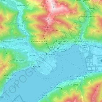
Name: Locarno topographic map, elevation, terrain.
Average elevation: 1,995 ft
Minimum elevation: 604 ft
Maximum elevation: 6,640 ft
Make a donation
Gear up for your next adventure:
As an Amazon Associate, this site earns from qualifying purchases at no extra cost to you.
Other topographic maps
Click on a map to view its topography, its elevation and its terrain.