Geolocate

Canmer topographic map

Click on the map to display elevation.

About this map

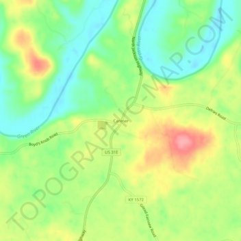
Name: Canmer topographic map, elevation, terrain.

Location: Canmer, Hart County, Kentucky, United States (37.27033 -85.78719 37.31033 -85.74719)

Average elevation: 607 ft

Minimum elevation: 472 ft

Maximum elevation: 787 ft

Hart County trails, hiking, mountain biking, running and outdoor activities

Other topographic maps

Click on a map to view its topography, its elevation and its terrain.

Munfordville

United States > Kentucky > Hart County

Average elevation: 627 ft

Horse Cave

United States > Kentucky > Hart County

Average elevation: 679 ft

Bonnieville

United States > Kentucky > Hart County

Average elevation: 696 ft

Gear up for your next adventure:

🔊Portable Camp Speaker - Music and alerts at camp
🥘Titanium Cookware - Durable, featherlight pots and pans for backpacking
🛶Inflatable Kayak - Portable kayak for rivers, lakes, and expeditions
🪶Survival Guide Book - Expert advice for emergency preparedness
🥤Water Filter Bottle - All‑in‑one filter bottle for safe hydration

As an Amazon Associate, this site earns from qualifying purchases at no extra cost to you.