
Sternwarte topographic map
Interactive map
Click on the map to display elevation.
About this map
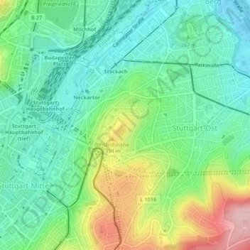
Name: Sternwarte topographic map, elevation, terrain.
Average elevation: 928 ft
Minimum elevation: 715 ft
Maximum elevation: 1,381 ft
Other topographic maps
Click on a map to view its topography, its elevation and its terrain.
Stuttgart
Allemagne > Bade-Wurtemberg > Stuttgart
Stuttgart, Regierungsbezirk Stuttgart, Bade-Wurtemberg, 70173, Allemagne
Average elevation: 1,158 ft
Sonnenberg
Allemagne > Bade-Wurtemberg > Stuttgart
Sonnenberg, Möhringen, Stuttgart, Bade-Wurtemberg, Allemagne
Average elevation: 1,352 ft
Stuttgart-West
Allemagne > Bade-Wurtemberg > Stuttgart
Stuttgart-West, Stuttgart, Regierungsbezirk Stuttgart, Bade-Wurtemberg, Allemagne
Average elevation: 1,181 ft