
Sonnenberg topographic map
Interactive map
Click on the map to display elevation.
About this map
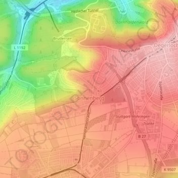
Name: Sonnenberg topographic map, elevation, terrain.
Location: Sonnenberg, Möhringen, Stuttgart, Bade-Wurtemberg, Allemagne (48.73636 9.13532 48.74948 9.16151)
Average elevation: 1,352 ft
Minimum elevation: 968 ft
Maximum elevation: 1,555 ft
Other topographic maps
Click on a map to view its topography, its elevation and its terrain.
Sternwarte
Allemagne > Bade-Wurtemberg > Stuttgart
Sternwarte, 41, Zur Uhlandshöhe, Uhlandshöhe, Stuttgart-Ost, Stuttgart, Bade-Wurtemberg, 70188, Allemagne
Average elevation: 928 ft
Stuttgart
Allemagne > Bade-Wurtemberg > Stuttgart
Stuttgart, Regierungsbezirk Stuttgart, Bade-Wurtemberg, 70173, Allemagne
Average elevation: 1,158 ft
Stuttgart-West
Allemagne > Bade-Wurtemberg > Stuttgart
Stuttgart-West, Stuttgart, Regierungsbezirk Stuttgart, Bade-Wurtemberg, Allemagne
Average elevation: 1,181 ft