
Make a donation
Gear up for your next adventure:
As an Amazon Associate, this site earns from qualifying purchases at no extra cost to you.
Oesede topographic map
Click on the map to display elevation.
Make a donation
Gear up for your next adventure:
As an Amazon Associate, this site earns from qualifying purchases at no extra cost to you.
Oesede
Oesede liegt an der Düte im Osnabrücker Land inmitten des Osnabrücker Hügellandes. Im Süden wird es durch den Teutoburger Wald (dessen alter Name Osning ist) begrenzt, einem Teil des Natur- und Geoparks TERRA.vita. Die Höhenlage an der Düte beträgt 64 m ü. NHN. Der höchste Punkt der Siedlung befindet sich am Musenberg bei 190 m ü. NHN.
Make a donation
Gear up for your next adventure:
As an Amazon Associate, this site earns from qualifying purchases at no extra cost to you.
About this map
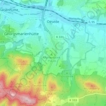
Name: Oesede topographic map, elevation, terrain.
Average elevation: 489 ft
Minimum elevation: 272 ft
Maximum elevation: 1,070 ft
Make a donation
Gear up for your next adventure:
As an Amazon Associate, this site earns from qualifying purchases at no extra cost to you.
Other topographic maps
Click on a map to view its topography, its elevation and its terrain.
Kloster Oesede
Deutschland > Niedersachsen > Landkreis Osnabrück > Georgsmarienhütte > Kloster Oesede
Average elevation: 410 ft
Harderberg
Deutschland > Niedersachsen > Landkreis Osnabrück > Georgsmarienhütte > Harderberg
Average elevation: 381 ft
Dörenberg
Deutschland > Niedersachsen > Landkreis Osnabrück > Georgsmarienhütte
Average elevation: 656 ft
Lammersbrink
Deutschland > Niedersachsen > Landkreis Osnabrück > Georgsmarienhütte
Average elevation: 505 ft
Make a donation
Gear up for your next adventure:
As an Amazon Associate, this site earns from qualifying purchases at no extra cost to you.
Dörenberg
Deutschland > Niedersachsen > Landkreis Osnabrück > Georgsmarienhütte
Average elevation: 656 ft