
Make a donation
Gear up for your next adventure:
As an Amazon Associate, this site earns from qualifying purchases at no extra cost to you.
Boston Harbor topographic map
Click on the map to display elevation.
Make a donation
Gear up for your next adventure:
As an Amazon Associate, this site earns from qualifying purchases at no extra cost to you.
About this map
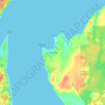
Name: Boston Harbor topographic map, elevation, terrain.
Location: Boston Harbor, Thurston County, Washington, United States (47.11855 -122.92167 47.15855 -122.88167)
Average elevation: 43 ft
Minimum elevation: 0 ft
Maximum elevation: 187 ft
Thurston County trails, hiking, mountain biking, running and outdoor activities
Make a donation
Gear up for your next adventure:
As an Amazon Associate, this site earns from qualifying purchases at no extra cost to you.
Other topographic maps
Click on a map to view its topography, its elevation and its terrain.
Mima Mounds Natural Area Preserve
United States > Washington > Thurston County
Average elevation: 203 ft