Geolocate

Eve topographic map

Click on the map to display elevation.

About this map

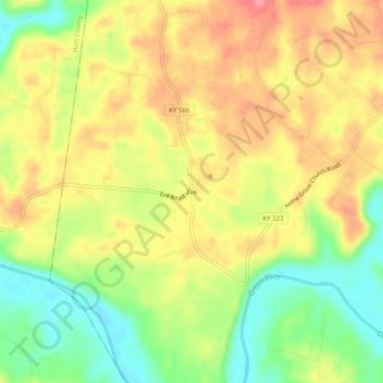
Name: Eve topographic map, elevation, terrain.

Location: Eve, Green County, Kentucky, United States (37.29117 -85.69858 37.33117 -85.65858)

Average elevation: 643 ft

Minimum elevation: 486 ft

Maximum elevation: 781 ft

Green County trails, hiking, mountain biking, running and outdoor activities

Gear up for your next adventure:

🧤Tactile Hiking Gloves - Keep hands warm while operating GPS and smartphone screens
🔭Stargazing Telescopes - Perfect for camping in low-light pollution areas shown on maps
🚁Photography Drones - Capture stunning aerial views of landforms and topography
🌡️Handheld Weather Meters - Measure wind, temp, and pressure for safe mountain travel
🔦Compact Flashlight - Reliable flashlight for emergencies

As an Amazon Associate, this site earns from qualifying purchases at no extra cost to you.