
Hatfield topographic map
Click on the map to display elevation.
About this map
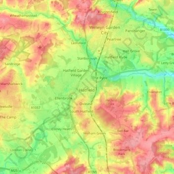
Name: Hatfield topographic map, elevation, terrain.
Average elevation: 295 ft
Minimum elevation: 151 ft
Maximum elevation: 436 ft
Other topographic maps
Click on a map to view its topography, its elevation and its terrain.
Welwyn Garden City
United Kingdom > England > Hertfordshire > Welwyn Hatfield
Average elevation: 292 ft
Ellenbrook Fields
United Kingdom > England > Hertfordshire > Welwyn Hatfield > Hatfield
Average elevation: 262 ft
Mardley Heath
United Kingdom > England > Hertfordshire > Welwyn Hatfield > Oaklands
Average elevation: 361 ft
Gobions Pond
United Kingdom > England > Hertfordshire > Welwyn Hatfield > Brookmans Park > Swanley Bar
Average elevation: 348 ft
Stanborough Park
United Kingdom > England > Hertfordshire > Welwyn Hatfield > Hatfield > Stanborough
Average elevation: 259 ft
Mardleybury
United Kingdom > England > Hertfordshire > Welwyn Hatfield > Woolmer Green
Average elevation: 358 ft
Great Wood Northaw Country Park
United Kingdom > England > Hertfordshire > Welwyn Hatfield > Hatfield
Average elevation: 348 ft
Mill Green
United Kingdom > England > Hertfordshire > Welwyn Hatfield > Hatfield
Average elevation: 266 ft