
Make a donation
Gear up for your next adventure:
As an Amazon Associate, this site earns from qualifying purchases at no extra cost to you.
Stanborough topographic map
Click on the map to display elevation.
Make a donation
Gear up for your next adventure:
As an Amazon Associate, this site earns from qualifying purchases at no extra cost to you.
About this map
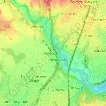
Name: Stanborough topographic map, elevation, terrain.
Average elevation: 266 ft
Minimum elevation: 177 ft
Maximum elevation: 361 ft
Make a donation
Gear up for your next adventure:
As an Amazon Associate, this site earns from qualifying purchases at no extra cost to you.
Other topographic maps
Click on a map to view its topography, its elevation and its terrain.
Mardley Heath
United Kingdom > England > Hertfordshire > Welwyn Hatfield > Oaklands
Average elevation: 361 ft
Gobions Pond
United Kingdom > England > Hertfordshire > Welwyn Hatfield > Brookmans Park > Swanley Bar
Average elevation: 348 ft
Make a donation
Gear up for your next adventure:
As an Amazon Associate, this site earns from qualifying purchases at no extra cost to you.
Stanborough Park
United Kingdom > England > Hertfordshire > Welwyn Hatfield > Hatfield > Stanborough
Average elevation: 259 ft
Great Wood Northaw Country Park
United Kingdom > England > Hertfordshire > Welwyn Hatfield > Hatfield
Average elevation: 348 ft
Make a donation
Gear up for your next adventure:
As an Amazon Associate, this site earns from qualifying purchases at no extra cost to you.
Ellenbrook Fields
United Kingdom > England > Hertfordshire > Welwyn Hatfield > Hatfield
Average elevation: 262 ft
Make a donation
Gear up for your next adventure:
As an Amazon Associate, this site earns from qualifying purchases at no extra cost to you.