Geolocate

Nacoochee topographic map

Click on the map to display elevation.

About this map

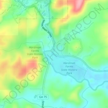
Name: Nacoochee topographic map, elevation, terrain.

Location: Nacoochee, White County, Georgia, 30545, United States (34.67510 -83.72046 34.69510 -83.70046)

Average elevation: 1,473 ft

Minimum elevation: 1,325 ft

Maximum elevation: 1,762 ft

White County trails, hiking, mountain biking, running and outdoor activities

Other topographic maps

Click on a map to view its topography, its elevation and its terrain.

Helen

United States > Georgia > White County

Average elevation: 1,601 ft

Cleveland

United States > Georgia > White County

Average elevation: 1,572 ft

Unicoi State Park

United States > Georgia > White County > Helen

Average elevation: 1,772 ft

Yonah

United States > Georgia > White County > Yonah

Average elevation: 1,611 ft

Helen

United States > Georgia > White County

Average elevation: 1,601 ft

Cleveland

United States > Georgia > White County

Average elevation: 1,572 ft

Cleveland

United States > Georgia > White County

Average elevation: 1,572 ft

Gear up for your next adventure:

🔭Stargazing Telescopes - Perfect for camping in low-light pollution areas shown on maps
📦Dry Bags Set - Waterproof storage for electronics and clothes
📦Gear Storage Bags - Organize and protect outdoor equipment
🪶Camping Sleeping Pad - Comfortable sleeping pad for backpacking
🪑Portable Camp Table - Compact table for campsite meals

As an Amazon Associate, this site earns from qualifying purchases at no extra cost to you.