Geolocate

Andover topographic map

Click on the map to display elevation.

About this map

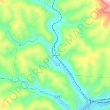
Name: Andover topographic map, elevation, terrain.

Location: Andover, Wise County, Virginia, 24215, United States (36.90371 -82.81655 36.94371 -82.77655)

Average elevation: 2,021 ft

Minimum elevation: 1,627 ft

Maximum elevation: 2,713 ft

Wise County trails, hiking, mountain biking, running and outdoor activities

Gear up for your next adventure:

🥾Women's Hiking Boots - Top-rated trail boots with ankle support and superior grip
🗺️NatGeo Topo Maps - High-quality waterproof printed topographic maps of US Parks
🧢Outdoor Hiking Hat - Sun protection hat for outdoor explorers
😴Insulated Sleeping Pads - Compact and warm pads for high-elevation camping
📡GPS Antenna Upgrade - Enhance GPS reception in remote terrain

As an Amazon Associate, this site earns from qualifying purchases at no extra cost to you.