
Make a donation
Gear up for your next adventure:
As an Amazon Associate, this site earns from qualifying purchases at no extra cost to you.
Bierenbachtal topographic map
Click on the map to display elevation.
Make a donation
Gear up for your next adventure:
As an Amazon Associate, this site earns from qualifying purchases at no extra cost to you.
Bierenbachtal
Bierenbachtal liegt im nordöstlichen Teil der oberbergischen Gemeinde Nümbrecht auf einer Höhe von etwa 230 bis 250 m über NHN. Der Ort zieht sich entlang des namensgebenden Tales von der Mündung in die Bröl hinauf zur Gemeindegrenze zwischen Nümbrecht und Wiehl in nordwestlicher bzw. nach Oberbierenbach in nordöstlicher Richtung. Die Entfernung zu den Ortszentren von Nümbrecht und Wiehl beträgt etwa 2 Kilometer. Weitere Städte in der Nähe sind Gummersbach (ca. 15 km nördlich), Siegen (ca. 40 km südöstlich) und die rheinische Metropole Köln (ca. 50 km westlich).
Make a donation
Gear up for your next adventure:
As an Amazon Associate, this site earns from qualifying purchases at no extra cost to you.
About this map
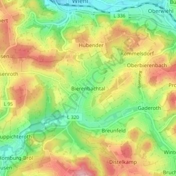
Name: Bierenbachtal topographic map, elevation, terrain.
Average elevation: 846 ft
Minimum elevation: 614 ft
Maximum elevation: 1,122 ft
Make a donation
Gear up for your next adventure:
As an Amazon Associate, this site earns from qualifying purchases at no extra cost to you.
Other topographic maps
Click on a map to view its topography, its elevation and its terrain.
Kurpark Nümbrecht
Deutschland > Nordrhein-Westfalen > Oberbergischer Kreis > Nümbrecht > Ödinghausen
Average elevation: 919 ft
Schloss Homburg
Deutschland > Nordrhein-Westfalen > Oberbergischer Kreis > Nümbrecht > Homburg-Bröl > Unter der Hardt
Average elevation: 843 ft
Guxmühlen
Deutschland > Nordrhein-Westfalen > Oberbergischer Kreis > Nümbrecht > Marienberghausen
Auf der Hardt | Abbenroth | Ahebruch | Ahlbusch | Alsbach | Altennümbrecht | Bierenbachtal | Breunfeld | Benroth | Berkenroth | Birkenbach | Breitewiese | Brünglinghausen | Bruch | Büschhof | Buch | Distelkamp | Drinsahl | Elsenroth | Erlinghausen | Friedenthal | Gaderoth | Gerhardsiefen | Geringhausen |…
Average elevation: 814 ft