Geolocate

Monte Marzo topographic map

Click on the map to display elevation.

About this map

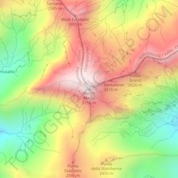
Name: Monte Marzo topographic map, elevation, terrain.

Location: Monte Marzo, Valprato Soana, Torino, Piemonte, Italia (45.56241 7.60873 45.56251 7.60883)

Average elevation: 7,608 ft

Minimum elevation: 6,089 ft

Maximum elevation: 8,983 ft

Gear up for your next adventure:

🔋Rechargeable Batteries - Power up your outdoor devices
📶Vehicle Signal Boosters - Improve reception in rural areas while driving to trailheads
🧣Hiking Neck Gaiter - Multi‑use neck protection for outdoor weather
🦟Ultrasonic Repellers - Create a bug-free zone at your camp or rest stop
🪶Multi‑Purpose Knife - Useful blade for camp and trail

As an Amazon Associate, this site earns from qualifying purchases at no extra cost to you.