
Make a donation
Gear up for your next adventure:
As an Amazon Associate, this site earns from qualifying purchases at no extra cost to you.
West End topographic map
Click on the map to display elevation.
Make a donation
Gear up for your next adventure:
As an Amazon Associate, this site earns from qualifying purchases at no extra cost to you.
About this map
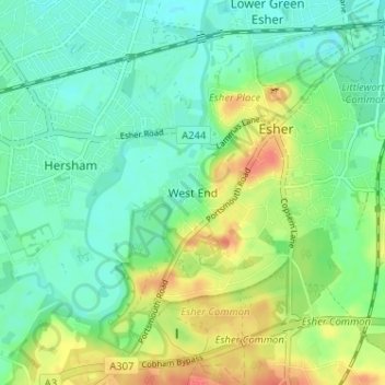
Name: West End topographic map, elevation, terrain.
Location: West End, Elmbridge, Surrey, England, KT10 8LY, United Kingdom (51.34275 -0.39929 51.38275 -0.35929)
Average elevation: 79 ft
Minimum elevation: 26 ft
Maximum elevation: 177 ft
Make a donation
Gear up for your next adventure:
As an Amazon Associate, this site earns from qualifying purchases at no extra cost to you.
Other topographic maps
Click on a map to view its topography, its elevation and its terrain.
Cobham
United Kingdom > England > Surrey > Elmbridge
The River Mole runs through Cobham, with a visitor area and well-surfaced path by the mill in the High Street, dividing the low-rise urban village/town centre from the remaining agricultural parts of Cobham in the west and south. This can flood small, old parts of the village centre in extreme rainfall.…
Average elevation: 92 ft