
Make a donation
Gear up for your next adventure:
As an Amazon Associate, this site earns from qualifying purchases at no extra cost to you.
Schönried topographic map
Click on the map to display elevation.
Make a donation
Gear up for your next adventure:
As an Amazon Associate, this site earns from qualifying purchases at no extra cost to you.
Schönried
Die Wohngebiete liegen auf einer Höhe von 1190 m bis 1327 m. Schönried verfügt über ein eigenes Schulhaus (Primarschule), eine Poststelle, eine Käserei und einige Geschäfte.
Make a donation
Gear up for your next adventure:
As an Amazon Associate, this site earns from qualifying purchases at no extra cost to you.
About this map
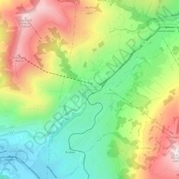
Name: Schönried topographic map, elevation, terrain.
Average elevation: 4,580 ft
Minimum elevation: 3,314 ft
Maximum elevation: 6,306 ft
Make a donation
Gear up for your next adventure:
As an Amazon Associate, this site earns from qualifying purchases at no extra cost to you.
Other topographic maps
Click on a map to view its topography, its elevation and its terrain.
Make a donation
Gear up for your next adventure:
As an Amazon Associate, this site earns from qualifying purchases at no extra cost to you.
Saanen
Schweiz > Bern > Verwaltungskreis Obersimmental-Saanen
Eine befestigte Höhensiedlung vermutlich aus der Bronzezeit bestand auf dem Cholis Grind. Saanen wurde 1228 als Gissinay erwähnt, 1340 als Sanon und französisch Gessenay. Den Turm Schwabenried gab es seit etwa dem Jahr 1000, und die Kramburg, die 1331 erweitert wurde, lag an den Saumwegen ins Wallis und in…
Average elevation: 5,007 ft