Geolocate

Cambridge topographic map

Click on the map to display elevation.

About this map

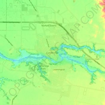
Name: Cambridge topographic map, elevation, terrain.

Location: Cambridge, Waipa District, Waikato, 3434, New Zealand (-37.93179 175.42911 -37.85179 175.50911)

Average elevation: 233 ft

Minimum elevation: 72 ft

Maximum elevation: 495 ft

Gear up for your next adventure:

🎒Hydration Pack - Hands‑free water reservoir for long hikes
Camping Coffee Makers - Enjoy premium coffee at the summit or campsite
🛡️Bear Spray Outdoor - Protection in bear country hikes
🧢Outdoor Hiking Hat - Sun protection hat for outdoor explorers
🚁Photography Drones - Capture stunning aerial views of landforms and topography

As an Amazon Associate, this site earns from qualifying purchases at no extra cost to you.