
Make a donation
Gear up for your next adventure:
As an Amazon Associate, this site earns from qualifying purchases at no extra cost to you.
Eisenerz topographic map
Click on the map to display elevation.
Make a donation
Gear up for your next adventure:
As an Amazon Associate, this site earns from qualifying purchases at no extra cost to you.
Eisenerz
A few miles northwest of Eisenerz stands Leopoldstein Castle, and near it Leopoldstein Lake. This lake, with its dark green water at an elevation of 2,028 feet (618 m), and surrounded on all sides by high peaks, is not large and has a depth of 100 ft (30 m).
Make a donation
Gear up for your next adventure:
As an Amazon Associate, this site earns from qualifying purchases at no extra cost to you.
About this map
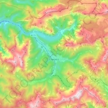
Name: Eisenerz topographic map, elevation, terrain.
Location: Eisenerz, Bezirk Leoben, Styria, 8790, Austria (47.48237 14.80499 47.61450 14.98340)
Average elevation: 4,209 ft
Minimum elevation: 1,821 ft
Maximum elevation: 7,018 ft
Make a donation
Gear up for your next adventure:
As an Amazon Associate, this site earns from qualifying purchases at no extra cost to you.
Other topographic maps
Click on a map to view its topography, its elevation and its terrain.