
Make a donation
Gear up for your next adventure:
As an Amazon Associate, this site earns from qualifying purchases at no extra cost to you.
Reconvilier topographic map
Click on the map to display elevation.
Make a donation
Gear up for your next adventure:
As an Amazon Associate, this site earns from qualifying purchases at no extra cost to you.
Reconvilier
Die Fläche des 8,2 km² grossen Gemeindegebiets umfasst einen Abschnitt des westlichen Teils des Vallée de Tavannes, das bei Reconvilier eine Breite von 3 km aufweist. Zwischen den Flussläufen der Birs und des linken Zuflusses Trame befinden sich mehrere kleine Hügel, darunter der Haut de Spont (828 m ü. M.) und der Châtillon (822 m ü. M.). Ganz im Westen reicht das Gebiet in einem schmalen Zipfel in die Forêt de Chaindon. Südlich der Birsniederung erstreckt sich das Gemeindegebiet bis auf die Jurakette des Montoz, welcher das gesamte Vallée de Tavannes auf seiner Südseite flankiert. Auf der Höhe des Montoz wird mit 1312 m ü. M. der höchste Punkt von Reconvilier erreicht. Von der Gemeindefläche entfielen 1997 12 % auf Siedlungen, 42 % auf Wald und Gehölze und 46 % auf Landwirtschaft.
Make a donation
Gear up for your next adventure:
As an Amazon Associate, this site earns from qualifying purchases at no extra cost to you.
About this map
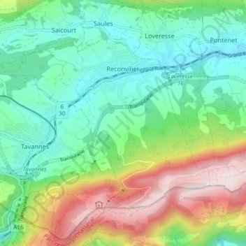
Name: Reconvilier topographic map, elevation, terrain.
Average elevation: 2,963 ft
Minimum elevation: 2,323 ft
Maximum elevation: 4,281 ft
Make a donation
Gear up for your next adventure:
As an Amazon Associate, this site earns from qualifying purchases at no extra cost to you.