
Thank you for supporting this site ❤️
Make a donation
Make a donation
Gear up for your next adventure:
As an Amazon Associate, this site earns from qualifying purchases at no extra cost to you.
Bejgaon topographic map
Click on the map to display elevation.
Thank you for supporting this site ❤️
Make a donation
Make a donation
Gear up for your next adventure:
As an Amazon Associate, this site earns from qualifying purchases at no extra cost to you.
About this map
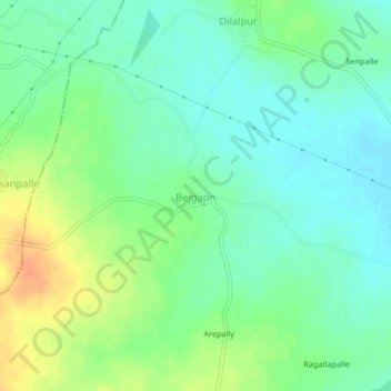
Name: Bejgaon topographic map, elevation, terrain.
Location: Bejgaon, Gajwel mandal, Siddipet, Telangana, 502301, India (17.90064 78.65498 17.94064 78.69498)
Average elevation: 1,778 ft
Minimum elevation: 1,729 ft
Maximum elevation: 1,864 ft
Thank you for supporting this site ❤️
Make a donation
Make a donation
Gear up for your next adventure:
As an Amazon Associate, this site earns from qualifying purchases at no extra cost to you.