Geolocate

Defiance topographic map

Click on the map to display elevation.

About this map

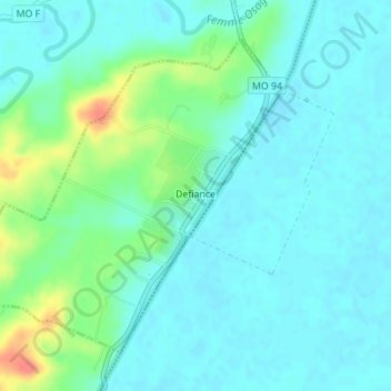
Name: Defiance topographic map, elevation, terrain.

Location: Defiance, Saint Charles County, Missouri, United States (38.62201 -90.79732 38.64369 -90.77126)

Average elevation: 499 ft

Minimum elevation: 453 ft

Maximum elevation: 653 ft

Saint Charles County trails, hiking, mountain biking, running and outdoor activities

Other topographic maps

Click on a map to view its topography, its elevation and its terrain.

Defiance

United States > Missouri > Saint Charles County

Average elevation: 502 ft

Howell

United States > Missouri > Saint Charles County > Harvester

Average elevation: 531 ft

Gear up for your next adventure:

🌡️Portable Weather Meter - Track weather conditions on the trail
🏕️Tent Footprint - Protect your tent base from wear
🧼Biodegradable Camping Soap - Eco‑friendly soap for outdoor hygiene
🗺️Topographic Maps - Detailed topo maps for hiking, exploring and outdoor navigation
🥘Titanium Cookware - Durable, featherlight pots and pans for backpacking

As an Amazon Associate, this site earns from qualifying purchases at no extra cost to you.