
Thank you for supporting this site ❤️
Make a donation
Make a donation
Gear up for your next adventure:
As an Amazon Associate, this site earns from qualifying purchases at no extra cost to you.
Erbach topographic map
Click on the map to display elevation.
Thank you for supporting this site ❤️
Make a donation
Make a donation
Gear up for your next adventure:
As an Amazon Associate, this site earns from qualifying purchases at no extra cost to you.
About this map
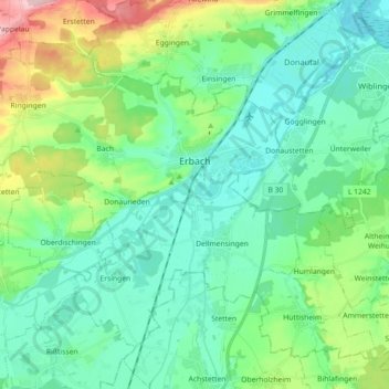
Name: Erbach topographic map, elevation, terrain.
Location: Erbach, Alb-Donau-Kreis, Baden-Württemberg, 89155, Germany (48.27019 9.76101 48.36412 9.94032)
Average elevation: 1,693 ft
Minimum elevation: 1,526 ft
Maximum elevation: 2,231 ft
Thank you for supporting this site ❤️
Make a donation
Make a donation
Gear up for your next adventure:
As an Amazon Associate, this site earns from qualifying purchases at no extra cost to you.