
Thank you for supporting this site ❤️
Make a donation
Make a donation
Gear up for your next adventure:
As an Amazon Associate, this site earns from qualifying purchases at no extra cost to you.
木洪 topographic map
Click on the map to display elevation.
Thank you for supporting this site ❤️
Make a donation
Make a donation
Gear up for your next adventure:
As an Amazon Associate, this site earns from qualifying purchases at no extra cost to you.
About this map
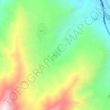
Name: 木洪 topographic map, elevation, terrain.
Location: 木洪, Xunhua, 海东市, Qinghai, China (35.66322 102.54460 35.70322 102.58460)
Average elevation: 9,147 ft
Minimum elevation: 7,684 ft
Maximum elevation: 11,385 ft
Thank you for supporting this site ❤️
Make a donation
Make a donation
Gear up for your next adventure:
As an Amazon Associate, this site earns from qualifying purchases at no extra cost to you.