
Make a donation
Gear up for your next adventure:
As an Amazon Associate, this site earns from qualifying purchases at no extra cost to you.
Morro Grande topographic map
Click on the map to display elevation.
Make a donation
Gear up for your next adventure:
As an Amazon Associate, this site earns from qualifying purchases at no extra cost to you.
About this map
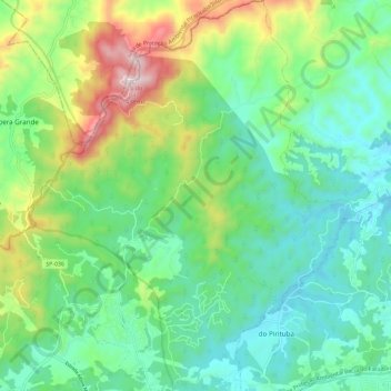
Name: Morro Grande topographic map, elevation, terrain.
Average elevation: 2,887 ft
Minimum elevation: 2,188 ft
Maximum elevation: 4,636 ft
Make a donation
Gear up for your next adventure:
As an Amazon Associate, this site earns from qualifying purchases at no extra cost to you.
Other topographic maps
Click on a map to view its topography, its elevation and its terrain.
Morro Grande
Brasil > São Paulo > Região Metropolitana de São Paulo > Guarulhos
Average elevation: 2,805 ft
Praça Vila Lobos
Brasil > São Paulo > Região Metropolitana de São Paulo > Guarulhos
Average elevation: 2,497 ft
Sesc Guarulhos
Brasil > São Paulo > Região Metropolitana de São Paulo > Guarulhos
Average elevation: 2,444 ft